Esoma-KE Logo
Change Class  |  Change Subject

Measuring Weather Elements and Weather Forecasting | Geography

  Change Class FORM ONE
Select Subject  |  Geography

GEOGRAPHY REVISION QUESTIONS

Click to Attempt Form 1 Geography Questions


Want to enjoy learning? Try reading without Ads!

Say goodbye to distractions and enjoy uninterrupted learning with our new ad-free feature. Dive into our vast collection of educational content without any interruptions.

Explore Ad-Free learning plus lots of other premium benefits for as little as KES 500 per month.


What is Weather?

Weather is the daily atmospheric condition of a place at a particular time.
Read More On

The elements of weather are:

  1. Temperature
  2. Humidity precipitation
  3. Precipitation
  4. Atmospheric pressure
  5. Wind
  6. Sunshine
  7. Cloud cover

A Weather Station

A place where observation, measuring and recording of weather elements is done.

Factors to Be Taken Into Account When Sitting a Weather Station

1. An open place where there is little obstruction of weather elements.
2. Accessible place so that recording can be done easily.
3. A fairly level or gently sloping ground (5◦) so that it's easy to position weather instruments.
4. The place should provide a wide view of the surrounding landscape and the sky.
5. The site should be free from flooding.
6. The place should have security

Instruments for Measuring Elements of Weather

1. Thermometer- temperature
2. Hygrometer- humidity
3. Rain gauge- rainfall
4. Barometer- air pressure
5. Sunshine recorder-sunshine duration and intensity
6. Wind vane- wind direction
7. Anemometer- wind speed
8. Evaporimeter-rate and amount of evaporation

A Stevenson Screen - Weather Form 1 Geography
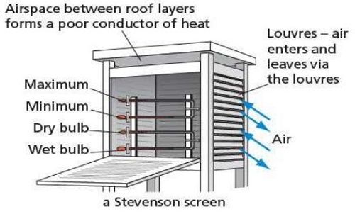
A Stevenson Screen
-A white wooden box mounted on four legs used to house thermometers and hygrometers.
The instruments which are found in it are:
  1. Maximum thermometer
  2. minimum thermometer
  3. Six's thermometer
  4. hygrometer-wet bulb and dry bulb thermometer
Importance
1. Provide shade conditions for accurate temperature recording
2. Ensure safety of thermometers because they are delicate.

Qualifications Which Make Stevenson Screen Suitable For Its Work

1. Painted white for little absorption of solar heat energy.
2. Made of wood which is a bad conductor of heat.
3. Well ventilated to allow easier flow of air inside it.
4. Raised to prevent contact with terrestrial radiation.
5. Has double roof which acts as an insulator to prevent direct heating from the sun.


Recording and Calculating Weather Conditions

Temperature

- Degree of hotness of an object or a place.
It's measured using 3 types of thermometers namely:
  1. Maximum thermometer
  2. Minimum thermometer
  3. Six's thermometer

Maximum Thermometer

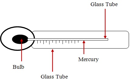
A MAXIMUM THERMOMETER - Weather Form 1 Geography
A Maximum Thermometer
- It's used to measure the highest temperature reached in a day.
- It uses mercury.
How a Maximum Thermometer is Used/Works
  • Temperature rises causing mercury to expand.
  • Mercury pushes the index up.
  • When temperature falls mercury contracts.
  • The maximum temperature is read from the scale at the lower end of the index.
  • Thermometer is reset by shaking it to force mercury back into the bulb.

Minimum Thermometer

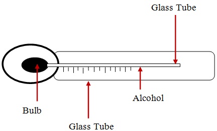
A Minimum Thermometer - Weather Form 1 Geography
A Minimum Thermometer
- It's used to record the lowest temperature reached in a day.
- It uses alcohol.
How A Minimum Thermometer Is Used/Works
  • Temperature falls causing alcohol to contract.
  • Alcohol pulls the index down.
  • When temperature rises alcohol expands and rises in the tube.
  • The index remains where it was pulled.
  • Minimum temperature reading is obtained from the scale at the lower end of the index.


Calculating Temperature

1. Diurnal/daily Temperature range
- Difference between the maximum and minimum temperature for any one day.
2. Mean Daily Temperature
- Average of the maximum and the minimum daily temperatures.
3. Mean Monthly temperature
- Sum of mean daily temperatures in a month divided by the number of days in that month.
4. Mean Monthly minimum Temperature
- Sum of daily minimum temperatures divided by the number of days in that month.
5. Mean Monthly Maximum Temperature
- Sum of daily maximum temperatures divided by the number of days in that month.
6. Mean Annual Temperature
- Sum of mean monthly temperatures divided by 12.
7. Mean Annual Temperature Range
- Difference between the highest and the lowest mean monthly temperatures in a year.
8. °k = °c + 273
9. °F = (°c x 1.8) + 32 derive the rest from the formulas

Rainfall

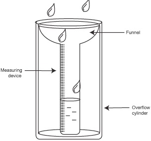
A Rain Gauge - Weather Form 1 Geography
A Rain Gauge
Rain gauge is the instrument used to measure the amount of rainfall in a day.
It should be made of impermeable material which can't absorb water.
How It's Used/Works
  • It's taken to an open space to prevent water from dropping into the funnel.
  • Its sunk into the ground to prevent evaporation
  • The funnel top is left 30cm above the ground to prevent splashes of water and run off.
  • After 24 hours water is emptied into the measuring cylinder.
  • The reading of the amount of rainfall is got from the measuring cylinder in millimetres.
  • The figure represents the millimetres of water falling on each square millimetre of the ground
  • It could be used to measure snow fall by melting it before the readings are gotten.


Calculating Rainfall

1. Monthly Rainfall Total
- Sum of rainfall recorded in a month.
2. Annual Rainfall Total
- Sum of monthly rainfall totals for 12 months.
3. Mean Monthly Rainfall
- Sum of rainfall totals for a particular month over several years divided by the number of the years of observation.
4. Mean Annual Rainfall
- Sum of mean monthly rainfall for 12 months of the year.


Sunshine

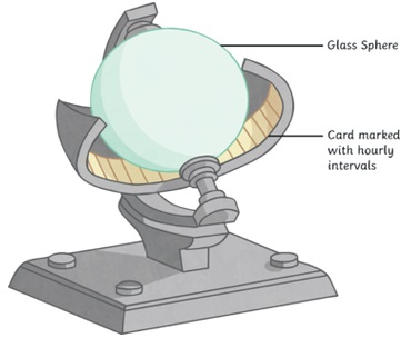
A Sunshine Recorder - Weather Form 1 Geography
A Sunshine Recorder
Duration of sunshine is measured using Campbell stokes sunshine recorder.
How It Works
  • Spherical lens focuses light on sensitized paper.
  • The paper burns when the sun is shining.
  • The total hours of sunshine is got by adding all the burnt sections from calibrations on the side of sensitized paper.
  • The sensitized paper is changed every day.


Humidity

- Humidity is the condition of atmosphere with reference to its water content.
- It's measured with hygrometer or psychrometer which consists of wet and dry bulb thermometers kept in Stevenson screen.
- Dry bulb thermometer is a thermometer covered with muslin bag immersed in water while dry bulb thermometer has no muslin
How It Works
When air is dry there is a lot of evaporation from the muslin.
  • Evaporation cools the bulb of thermometer resulting in a low temperature reading.
  • When humidity is high there is little evaporation from the muslin.
  • The wet bulb thermometer is cooled at a slower rate and both thermometers show almost the same temperature reading
  • The difference in readings between the two thermometers is used to determine relative humidity.
Dry bulb thermometer - Weather Form 1 Geography
Dry bulb thermometer

Interpretation of Hygrometer Readings

  • When the 2 readings are the same, relative humidity is 100% i.e. the air is saturated.
  • If the difference is small, humidity is high.
  • If the difference is big, humidity is very low.

Calculating Humidity

1. Absolute Humidity
Actual amount of water vapour a given volume of air can hold. It's expressed in g/m3
2. Specific Humidity
- Mass of water vapour in a given mass of air. It's expressed in g/km. Relative Humidity
- Ratio between the absolute humidity and the maximum amount of water the air can hold expressed in a percentage.
R.H. = A.H / Maximum amount of water the air can hold at the same temperature. Example
-If the air at 20°c contains 10g/m3 and given air can hold a maximum of 20g/m3.calculate the relative humidity.
10 x 100/20=50%

Wind

Direction

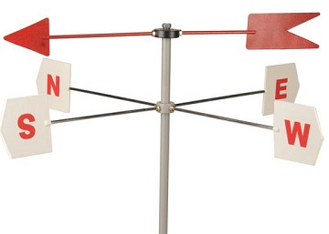
A Wind Vane - Weather Form 1 Geography
A Wind Vane
Wind direction is determined using wind vane.
How It Works
  • As the wind blows the arrow swings.
  • The arrow points in the opposite direction of the wind flow.
  • The direction is read from the cardinal compass points.
  • The arrow will point in the direction from which the wind is blowing.
  • For instance if it points S the wind is blowing from S towards N.

Wind Direction Using a Wind Sock

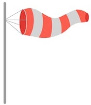
A Wind Sock - Weather Form 1 Geography
A Wind Sock
- Used to indicate the general direction of wind flow.
- Not kept in a weather station because it doesn't give the accurate direction of wind flow.
- Seen near airstrips and airports for the benefit of the pilots.
How it Works
  • When wind blows the bas stretches out in the direction that the wind is blowing.

Wind speed/Velocity

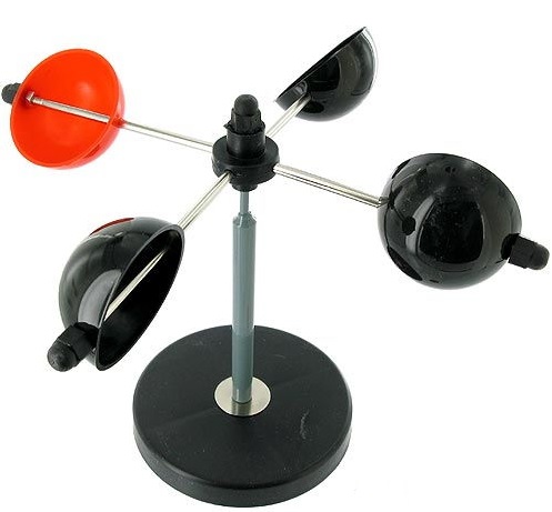
An Anemometer - Weather Form 1 Geography
An Anemometer
-Measured using anemometer.
How It Works
  • When wind bows hemispherical cups rotate.
  • The number of rotations is obtained from the metre on the lower part of the anemometer.
  • The units for measuring wind are called knots.


Atmospheric Pressure

- The force exerted by gases in the atmosphere on some area or body on the earths surface.
- Measured using barometers of three types namely mercury, aneroid and Fortin Barometers.

Mercury Barometer

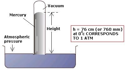
A Simple Mercury Barometer - Weather Form 1 Geography
A Simple Mercury Barometer
How It Works
  • Air exerts pressure on the mercury in the beaker.
  • The height of mercury in the tube is proportional to the atmospheric pressure.
  • The readings are taken in mmHg.
  • Its 760mmHg at sea level
Advantage of Mercury Barometer
- Quite accurate
Disadvantages of Mercury Barometer
- Cumbersome to carry around.
- Can be damaged quite easily while being carried around

Aneroid Barometer

- Measures changes in atmospheric pressure.
How It Works
  • Has air tight compartment (vacuum).
  • Compartment expands when pressure decreases.
  • It collapses when pressure increases.
  • The movement is transmitted by lever to a pointer on a dial.
  • The readings are in kg/cm3.


Evaporation

The rate and amount of evaporation is measured using piche and tank evaporimeters.

Piche Evaporimeter

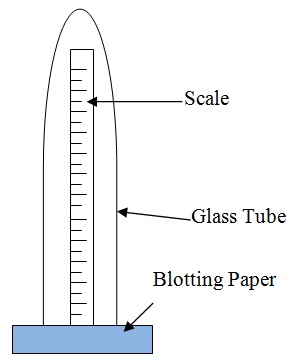
A Piche Evaporimeter - Weather Form 1 Geography
A Piche Evaporimeter
- When there is a lot of sunshine water evaporates from the blotting paper.
- The level of water in the glass tube reduces.
- The rate and amount of evaporation is got by looking at the scale on the outside of the glass tube.
- The units are in mm.

Tank Evaporimeter

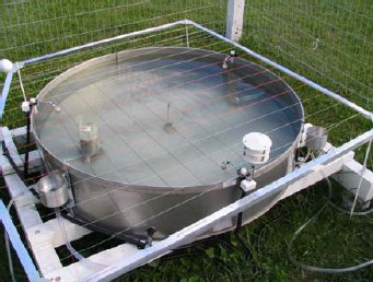
A Tank Evaporimeter - Weather Form 1 Geography
A Tank Evaporimeter
How It Works
  • The tank with water is put in the open.
  • Water evaporates when there is a lot of sunshine.
  • Water in the tank reduces.
  • The rate and amount of evaporation is got from calibrations in the inner side of the tank in mm.


Cloud Cover

- The amount of cloud cover is observed using eyes.
- It's given in oktas.
- Okta = approximately 1/8 of sky is covered with clouds.


Weather Forecasting

Prediction of the conditions of the atmosphere for a given place for a certain period.

Methods of Weather Forecasting

Traditional Methods of Weather Forecasting

- Examples of prediction of weather based on traditional beliefs and facts are.
  • Plants shedding leaves indicates period of drought.
  • Safari ants indicate it will rain.
  • Migration of butterflies also indicates it will rain.
  • Croaking of frogs during dry season indicate its going to rain.
  • Flowering of certain plants indicates the onset of rainfall.
  • Changes in the intensity of sunshine indicate its going to rain.

Modern Methods of Weather Forecasting

- Prediction of weather using modern instruments and new technology of collecting, transmitting, processing and analyzing weather data.
Instruments Used
1. Satellites - electronic devices which orbit the earth which collect and transmit weather data which is interpreted by computers.
2. Radar - an instrument used to see cloud formation.
3. Sensors/radiosondes - instrument fixed on a balloon used to measure atmospheric pressure, temperature and humidity.
4. Computers - electronic device used to store, analyze and display weather information.

Significance/Importance of Weather Forecasting

1. Helps us to be aware of natural calamities related to weather before they occur so as to take precautionary measures.
2. Guiding tourists on when to visit national parks.
3. Helps farmers to plan their activities such as planting, harvesting, etc.
4. Ensures air and water transport is carried out safely.
5. Helps sporting people to plan their training and competition schedules.
6. Helps people to plan many other activities such as mining, electricity generation, holiday events, etc.
7. Helps fishing communities to plan their activities.

Factors Hindering Weather Forecasting

1. Lack of skilled man power due to limited training facilities.
2. Lack of modern equipment leading to wrong forecasts.
3. Natural calamities such as storms and earthquakes.
4. Extreme weather conditions which may damage or displace instruments.
5. Use of faulty instruments.
6. Human error.
7. Poor sitting of instruments.


Factors Influencing Weather

Temperature

- These are the factors influencing temperature

1. Altitude

- Height above sea level.
- Temperature decreases with increase in height due to air at higher altitude being thinner and hence there is less particles e.g. gases, dust, smoke and water vapour to store heat so its rapidly lost to the outer space.

2. Latitude

- Distance from the equator.
- Temperature decreases with increase in latitude.
- Places neat equator experience high temperature due to the rays of the sun travelling a shorter distance facing less interference from atmospheric conditions hence more solar energy reaches the earths surface. Also the rays of the sun strike the earth at right angles hence solar energy is concentrated over a small area.
- At higher latitudes the rays of the sun travel a longer distance facing more interference from atmospheric conditions hence less solar energy reaches the earth's surface. Also the rays of the sun strike the earth at an acute angle hence solar energy is spread over a large area.

3. Aspect

- Direction of slope.
At higher latitudes slopes facing the equator have higher temperature because they face the sun while those facing the poles have lower temperature have lower temperature because they face away from the sun.

4. Winds

- Transfer heat from one place to another.
- When they blow from cool areas they take the cooling effect to the areas they blow over and when they blow from warm areas they take warming influence to the places they blow over.

5. Distance from a Large Water Body

- Areas near a large water body experience lower temperature during the hot season and higher temperature during the cool season due to sea breezes, warm and cold ocean currents and wind blowing over water which could be either warmer or cooler than the adjacent land.

6. Cloud Cover

- Clouds reduce the amount of solar energy reaching the surface by absorbing, scattering and reflecting solar radiation.
- When there are clear skies during the day the temperature is higher due to the earth receiving maximum solar insolation.
- During clear nights there are very low temperatures due to a lot of terrestrial radiation being lost to the outer space.
- Cloudy nights on the other hand are warmer due to clouds radiating to the earth heat absorbed during the day.

7. Length of Day

- The longer the period of solar insolation the greater the quantity of radiation a place receives and hence the more the heat that will be generated by the earth and vice versa.

8. Solar Altitude

- At equinox when the earth is farthest from the sun the temperature on the earth is lower due to less solar radiation reaching the earth's surface due to travelling a longer distance and hence facing great interference from atmospheric conditions.
- At solstices the earth receives more solar energy due to travelling a shorter distance and hence facing less interference from atmospheric conditions.

9. Solar Input

- Sometimes the sun gives out more heat due to reactions being violent causing temperature on the earth to be higher.
- When it gives out less heat the temperature on the earth is lower.

10. Surface Conditions

- Light surfaces e.g. smooth surfaces reflect sunlight and hence less solar energy reaches the earth's surface.
- Dark and irregular surfaces such as with vegetation absorb more heat leading to higher surface temperatures.


Humidity

Factors Influencing Humidity

1. Temperature

- Places with high temperature experience high humidity due to high evaporation and air having high capacity to hold moisture.
- Places with low temperature have low humidity due to low evaporation and air having low capacity to hold moisture.

2. Source of Moisture

- Areas near water bodies e.g. Kisumu and Mombasa experience high humidity due to evaporation of water from the water body.
- Places near thick vegetation also have high humidity due to evapotranspiration.
- Areas far away from water bodies such as the middle of deserts have low humidity.
- Areas receiving heavy rainfall also have high humidity.

3. Air Pressure

- There is high humidity at low altitudes because high pressure compresses air warming it increasing its capacity to hold moisture and also causes high evaporation.
- There is low pressure at high altitudes because air expands and cools thus reducing its capacity to hold moisture.

4. Latitude

- Low latitudes experience high humidity due to high temperatures resulting into high rates of evaporation and air having high capacity to hold moisture.
- High latitudes experience low humidity due to low temperatures resulting into low rates of evaporation and air having low capacity to hold moisture.

Significance of Humidity/Moisture

1. Affects rain formation in such as way that places with high humidity are likely to experience higher rainfall than those with low humidity.
2. Regulates the heat loss from the earth's surface by absorbing terrestrial radiation (process in which the earth gives off heat into the atmosphere).
3. It affects sensible temperature in that the higher the humidity the more we experience sensible temperature.
Hello Esoma-KE Member, please help review these notes.    Why review

Your review has been successfully submitted.
Tell us what you think about the notes.

Submit Comment

Students' and Teachers' Reviews


Here's what our users had to say ...

No comments given yet! Be the first to comment.